KHED


Khed (17° 40' N, 73° 20' E; p. 6477), the headquarters of Khed taluka, stands at the head of the Jagbudi river. Surrounded by hills, the town is oppressively hot during March, April and May. Its trade is carried on during the fair season only. A motorable road by Dapoli connects Khed with Harnai port at a distance of twenty-six miles and Satara is reached by a well-built road over the Amba-vali Ghat. An all-weather motorable road connecting it with Chiplun 24 miles south, and with Poladpur, twenty-three miles north, forms part of the Bombay-Konkan-Goa State Highway and places Khed in indirect communication with the routes to the Deccan by the Kumbharli and Mahabaleshvar Ghats. Boats of light draught work up on the tide from Dabhol and Anjanvel to Khed. The nearest railway station is Karad, 85 miles to the south-east.

Of the total population of 6,477, according to the Census figures of 1951, the agricultural classes number 1,125 and the non-agricultural classes 5,352. Of the latter, 1,061 persons derive their principal means of livelihood from production other than cultivation; 1,529 persons from Commerce; 260 persons from transport; and 2,502 persons from other services and miscellaneous sources.

Municipality.

The Khed municipality was established on 1st April, 1940, and is now governed under the Bombay District Municipal Act, 1901. It consists of 12 elected members; one seat is reserved for women and one seat for Scheduled Castes. The municipality elects, besides the managing committee, school, dispensary and sanitary committees.

In 1957-58, the total income of the municipality, excluding extraordinary and debt heads, totalled to Rs. 1,84,483, municipal rates and taxes being Rs. 1,36,454, revenue derived from municipal property and powers apart from taxation, Rs. 9,011, grants and contributions Rs. 20,153 and miscellaneous Rs. 18,865. The total expenditure for the same year, excluding extra-ordinary and debt heads, amounted to Rs. 2,94,236, composed of general administration and collection charges, Rs. 29,825, public safety Rs. 9,822, public health and convenience Rs. 1,79,850, public works Rs. 55,937, public instruction Rs. 3,149 and miscellaneous Rs. 15,653.

The water supply is from two nallas. The water of these nallas is stored by means of a weir and is brought to the town through pipes worked on the principle of gravitation. The weir works are located six miles away from Khed. A new water works scheme has been approved by Government, who have agreed to give 50 per cent, of the cost as grant-in-aid. The municipality has raised a loan of Rs. 1,80,000, towards meeting the cost.

There is no proper drainage system. Sullage is carried through stone-lined gutters. Some of it is carried to the river, but a portion is allowed to spread on the open land where it evaporates. Compost is prepared from this waste.

The municipality keeps a fire fighter.

There are about six and a half miles of roads of which three miles are metalled and the rest unmetalled.

The municipality has built a vegetable market having ten stalls. There is also a mutton market.

Compulsory primary education is managed by the District School Board. The municipality pays its annual statutory contribution. There is a high school conducted by the Khed Vyapari Dharmaday Education Society. The municipality pays a grant of Rs. 1,500 every year to this institution.

The municipality runs a dispensary with a maternity home attached to it.

There is a municipal park in the town as also two play-grounds under municipal management.

The municipality manages two cremation grounds for Hindus. There are four burial grounds for Muhammedans, managed privately by the community.

History.

No references to Khed have been traced. Before 1873, when it was made a separate Sub-Division, it was the head-quarters of a petty division under Dapoli or Suvarnadurg.

Rock Temples.

On the. side of a low hill to the east of the town are three small rock temples known as the 'Pandav Leni. Of their origin, nothing is locally known. Among several temples, none of architectural beauty, one is dedicated to the goddess Khedaji. There is also one Buddha Stupa.

Khed is being developed under Community Development Schemes There is a tailoring class, a tanning centre (1959), a training school in spinning and a basic school in carpentry and woodwork. Co-operative societies have been organized for various industries. Mahila Mandal and Youth Club, carry out social, cultural and sports activities. There is an inspection bungalow, for touring Government Officers. There is also a hostel for the boys of ex-servicemen in Khed, where free lodging and boarding is provided.

There are hot springs within the municipal limits.

PAWAS: Swami Swaroopanand


Sadguru Swami Swaroopanand, Pawas, Ratnagiri
Pawas is very famous for 
Swami Swaroopanand Samadhi Sthal 
Pavas (Ratnagiri T.; p. 3540), lying eight miles to the south of Ratnagiri has a river running through it. The village is separated from Ratnagiri by the Bhatye creek. The nearest railway station is Kolhapur, 92 miles to the south-east. The land is generally fertile. Some irrigated crops are raised on river water. There are also gardens of cocoanuts, betel-nuts and mangoes. Ranpar, the nearest harbour lies only at a distance of three miles. Agriculture is the main occupation of the village. Besides, people also undertake gardening and fishing. There are nine temples, four mosques, one secondary school and four primary schools in the village. Besides there is a primary health centre and a veterinary aid centre. Grants are given to various organisations to enable them to carry on recreational and social activities in the village.


Swami Swaroopananda one of the premier poet - saint of India a lumineries of the celebrated Nath Sampradaya

Swami Swaroopananda was born on Dec 15, 1903 in a pious brahmin family of Godbole who were ardent devotees of Lord Vishnu. His parents named him Ramchandra after Lord Rama ,the righteous king of Ayodhya who is worshipped as an incarnation of Lord Vishnu.
 

Swamiji was affectionately called 'appa' by his family and friends. From a very young age he displayed sharp intellect, good judgement, quick wit, fairness and immense leadership.
His exemplary behavior soon endeared him to everyone. He was an outstanding student and would have had a great future in any acedemic disipline, but swamiji had his sights set on higher goals. He had incarnated for a purpose. His keen desire and thirst for the supreme knowledge led him to his spiritual master 'Ganeshnath Maharaj' also known as 'Baba Maharaj Vaidya'. Through his grace Swamiji became a luminery of the Nath Sampradaya and took its teachings and practices to greater heights.
Swamiji was a firm believer in action. He cherished justice and freedom.
In his youth Swamiji plunged into the Indian freedom struggle first under the able leadership of Lokmanya Tilak -the fearless leader who took the opressors headlong and then became a satyagrahi as preached by Mahatma Gandhi - the political saint who gave the world the principle of non-voilent struggle.

Swamiji was a modern day saint and a reformist. He upheld the principle of simple living high thinking. He strived for equality of religions and world peace.

For more information, contact Swami Swaroopananda Seva Mandal, Pawas , District Ratnagiri, Maharashtra, India


SANGAMESHVAR


Sangameshvar (Sangameshvar T.; 17° 10' N, 73° 30' E; p. 3,494) is a town on the Shastri river about 20 miles from the coast. It has some trade in grain, piecegoods and salt fish. The river which was till 1850 navigable for the largest vessels to the very Sangameshvar quay, is now impassable for six miles lower down.

Sangameshvar's decline is chiefly due to the silting of the creek. The pack traffic through the Mala pass is, of imports, piecegoods and other articles. The trade is entirely in the hands of local merchants. On a much smaller scale, the system is the same as in Chiplun. Light booths are raised during the fair season, and a trading camp is formed, to be broken up at the first burst of the monsoon. The market on the hill side above the narrow river bank suffered almost every year from fire. Early in 1878 fifty-five houses were burnt, and a few weeks later (March 16th) a disastrous conflagration completely destroyed the mamlatdar's office, the treasury, the police lines and outbuildings, the post office, and seventy-five private houses. Up to the date of the 1878 fire, Sangameshvar was the head quarters of the sub-division, and had, in addition to the ordinary revenue and police offices, a subordinate judge's court and a post office. On the destruction of the public offices, the head-quarters of the sub-division were moved to the more central and convenient village of Devrukh.

Sangameshvar, the meeting of the Alaknanda and Varuna, is a place of some sanctity and of high antiquity. According to the Sahyadri Khand, it was originally called Ramakshetra and had temples built by Parashuram or Bhargavaram. In later times, perhaps, about the seventh century, a Chalukya king Karna, coming from Karvir or Kolhapur, made Sangameshvar his headquarters, and founding a city, built a fortress, temples and palaces. [The date of this Karna, who seems to be the same as the founder of the Mahalakshmi temple at Kolhapur (Jour. B. B. Roy. As. Soc. XI. 100), has not yet been fixed. The style of building is supposed (Jour. B. B. Roy. As. Soc. XI. 107) to point to some time about the eighth century A. D. At the same time, according to some verses in the Kolhapur Mahalakshmi temple, Karna flourished about A.D. 100 (30 Shalivahan) (Jcur. B. B. Roy. As. Soc. XI. 104), and according to the Sangameshvar Mahatmya he became king in 178 (S. 100). Jour. B. B. Roy. As. Soc. XI. 99.] Of the temples, one, called Karneshvar after its founder, remains. Sangameshvar continued for some time as the headquarters of Chalukya chief. It is mentioned in a Chalukya grant, probably of the eleventh or twelfth Century. [Jour. B. B. Roy. As. Soc. II. 263.] In the twelfth century it was for long the residence of Basav, the founder of the Lingayat sect. [Wilson's Meckenzie Collection, II. 4, 10.] In the sixteenth century it was the headquarters of a Bijapur governor. Barbosa (1514) speaks of it as Singuicar, a town of much commerce and merchandise with many ships from diverse ports. [Stanley's Barbosa. The Portuguese writers notice its exports of pepper and iron. DeCoutto, XII. 30.] It was also, though this was probably at Jayagad at the river mouth, a great stronghold of pirates. [Dom Joao de Castro (1538), apparently from the pirates infesting its mouth, calls Sangameshwar, the road of the Malbars. Primeiro Roteiro da Costa da India, 39.] In 1540, the Bijapur governor, scheming to make himself independent, asked for, but was refused Portuguese help. [DeCoutto, IV. 352.] In the seventeenth century (1670), it is spoken of as Zanguigara four leagues from Dabhol. [Ogilby's Atlas, V. 248.] Here, in 1689, Sambhaji, the son of Shivaji, was made a prisoner by Aurangzeb. Hamilton (1700-1720) calls it an excellent harbour, but adds that the country was frequented by Rabaris and was not inhabited. [New Account, I. 244.] In 1819, numbers of Vanjaris in the dry season gave Sangameshvar the look of a place of some importance. But it was in no way a town and had only a very small fixed population. [Collector to Gov. 15th July 1819; Revenue Diaries 142 of 1819, 2577. Some details of the present state of the Sangameshvar river are given under Jayagad'.]

Two miles up the river, in old Sangameshvar, called the Kasba, to distinguish it from the new town, peth, are several interesting temples. The chief of them is the temple of Karneshvar already referred to whose shrine is said to date from as far back as Parashuram. [Jour. B. B. Roy. As. Soc. XX. 100. According to Lieut. Dowell (1829) Karna repaired temples originally built by Parashuram. Mr. Dowell noticed that the chief temple was of the same age and style as the Kolhapur temple. There were then (1829) the remains of over a hundred ruined shrines. Bom. Rev. Rec. 225 of 1851, 273.] At present (1960) the wall on the eastern side is in ruins while other walls are intact. The worshipping gurav gets a cash allowance of Rs. 18 per month for his services in Karneshvar and other Sangameshvar temples. Kama the Chalukya (634) is said to have built or repaired 360 temples and granted the revenues of many villages for their support. Every year on Magh Vadya 15th (February-March) a fair is held attended by about 1,000 persons. At the meeting of the rivers are several sacred places, tirthas,among them one is known as the cleanser of sins, dhuta papa.

There are two high schools in the town. The Bombay-Konkan- Goa State Highway passes through Sangameshvar. There are two big bridges built on the rivers Shastri and Sonvi on this highway.

In 1953 and in 1958, Sangameshvar suffered heavily from floods to the Shastri River.

RAJAPUR

Photo: A village road in remote area of Rajapur taluka during rainy days. pic by Saraswat Mitra Magazine


Rajapur (Rajapur T.; 16° 35' N, 73° 30' E; p. 8,023), the head- quarters of Rajapur taluka is built on a slope rising from the water's edge, at the head of a tidal creek, thirty miles south-east of Ratnagiri and about fifteen miles from the sea. Rajapur is not now the port as it once was. Vessels cannot ply within three miles of the old stone quay. The bay, about three quarters of a mile broad, passes inland for about a mile between steep laterite cliffs. It is broken into several small coves and inlets, into the largest of which, Tulsanda, on the south side, small vessels caught in a south-west gale can run. Well sheltered from north-west gales, with westerly winds a heavy short swell makes it, except on the north side, a not very safe anchorage. [It is high water at full and change of the moon at 10 hours 45 minutes. Ordinary mean springs rise six feet five inches, neaps rise four feet five inches. Bom. Gov. Gazette, 3rd July 1879, 701.] Local vessels discharge and load at Jaitapur on the left bank of the river about four miles from the entrance, which among early European travellers shared with Rajapur, the honour of naming the river. There is only seven or eight feet of water on the bar at low tide, but further in abreast Jaitapur are depths of fror fifteen to twenty-four feet.

The oldest looking and best preserved town in the Konkan, its streets are steep and narrow and the markets paved and roofed. The old English factory, a massive stone building with an enclosure leading to the sea, now used as a Government office, and another equally large ruined European building probably the French Factory, give the town a special interest. The mamlatdar's office is situated in the old Dutch factory, purchased by English in 1699. it was closed in 1707. It was once a peculiar Ratnagiri port through which Arabs carried on their trade directly. [Nairne's Konkan, 121.] Now no foreign trader carries on trade through this port. The nearest railway station is Kolhapur, 80 miles to the south-east.

During the last century in the fair season active communication was kept up between Bombay, and the Deccan. Every year a few Arab vessels from Zanzibar and the African coast brought fresh and dry dates to exchange for gul and other produce. Now from Bombay piecegoods, metals and miscellaneous commodities, and from Malabar, cocoanuts and betelnuts are imported for local use and for through carriage to the Deccan. From the Deccan, to meet local wants come food grains, cotton cloth, molasses, turmeric, chillies, tobacco, clarified butter, edible oil, and other products. Mangoes and betelnuts are exported outside. The town is situated on the Bombay-Konkan-Goa National Highway, 48 miles away from Ratnagiri. It is connected with Kolhapur by road. The system of trade was similar to that at Chiplun and other old fashioned isolated Konkan towns. Business was in the hands of local merchants. Formerly it was an important trade centre. Goods from the Deccan and Bombay were consigned to the local merchants. On arrival they were sold and re-sold to petty dealers, continually changing hands until they were distributed amongst the consumers or reexported. The through trade was limited to the fair season (October-May), and as at Chiplun, during this busy time a large trading camp was formed, every available space near the market and the landing place being filled by temporary booths and warehouses. The conditions are now changed. It, is not so important a town as it was once. All essential commodities of life are imported and only mangoes and betelnuts, cashew-nuts and other forest products are exported. The chief streets are well-kept and paved, and the permanent shops are substantially built. During the hot months, March, April and May the streets are shaded from the sun by a continuous canopy of plaited cocoanut leaves, stretching from house to house and making a temporary arcade.

Communications.

There is direct communication with Kolhapur and the neighbouring Deccan districts by a provincial motorable road through the Phonda Ghat towards Nipani, and by an easy road over the Anaskura Ghat.

There are no industries in the town except fruit canning. Mango fruits are sliced and canned and are sent to U.S.A.

Population.

Of the total population of 8,023, according to the Census figures of 1951, the agricultural classes number 1,137 and the non-agricultural classes 6,886. Of the latter, 1,086 persons derive their principal means of livelihood from production other than cultivation; 2,118 persons from commerce; 388 persons from transport; and 3,294 persons from other services and miscellaneous sources.

Municipality.

Established in 1940, Rajapur Municipality has an area of 2.39 square miles. It is composed of 11 members and is now governed under the Bombay District Municipal Act, 1901. Besides the managing committee, there are committees for schools, dispensary and sanitation.

The annual income of the municipality for 1956-57, excluding extraordinary and debt heads amounted to Rs. 95,776; from municipal rates and taxes Rs. 85,617; revenue derived from municipal property and powers apart from taxation Rs. 1,873; grants and contributions Rs. 6,769; and miscellaneous Rs. 1,517. The expenditure for the same year, excluding extraordinary and debt heads amounted to Rs. 79,351; general administration and collection charges being Rs. 18,915; public safety Rs. 17,180; public health and convenience Rs. 37,707; grants and contributions Rs. 300; and miscellaneous Rs. 5,249.

Water supply in the town is mostly from private and public wells, municipal water works and tanks. The municipality has constructed one dam at Kodavli, from which water is carried to the town reservoir through pipes.

There are 6,931 ft. of underground and 18,091 of open drains in the town. During the year 1956-57, the municipality had constructed new drains, measuring 127 ft., out of which some are kaccha and some are stone-lined gutters. Water is collected in 25 cesspools, connected to the houses.

For fire-fighting the municipality has purchased one fire-fighter-cum-water-sprinkler, the same being also employed for sprinkling water on the streets.

The town has three furlongs of asphalted road, five miles, one furlong and 142 feet metalled and one mile six furlongs unmetalled.

Primary education in the town is managed by the District School Board, the municipality paying its annual statutory contribution. Rajapur High School is run by the Shikshan Prasarak Mandal, the municipality paying an annual contribution of Rs. 1,000.

There is one allopathic dispensary called "Rajapur Municipal Dispensary" situated in ward No. 1. One veterinary dispensary run by Government is situated in ward No. 4. The municipality runs a maternity home which extends free service.

There are six burial places and six cremation grounds, all managed by the respective communities. Four are situated in ward No. 1, one in ward No. 2, three in ward No. 3, and four in ward No. 4.

The town has some places of interest like the Pundalik Temple, Pandavas' Temple and the old English factory building now used as the Mamlatdar's office.

History.

At the time of the first Musalman conquest (1312), Rajapur was the chief town of the district. [Jervis' Konkan, I. 81. As so many names along the Konkan coast are Grecized, it seems probable that Ptolemy's (150), Turannosboas is Rajapur.] In 1638, it is said to be one of the best Deccan maritime towns. [Mandelslo in Harris, II. 130.] In that year Courten's Association and East India Company formed a compact in 1649 by which the former was to retain its assuda Factory in Madagaskar while the port-to-port trade in India, was to be reserved to the latter and because of pepper and cardamoms, and freedom from Dutch interference, the offer was accepted. [Sir William Hunter. A History of British India, Vol. II, p. 115.] In 1660 and 1670, Shivaji invaded the town sacking the English factory. In 1673, it is mentioned as then a French and formerly an English factory. [Fryer's New Account, 59.] In the terms of a treaty with Shivaji, the factory was again established but it was never profitable. [Grant Duff, 118.] In 1686, after the unsuccessful expedition of Aurangzeb's son Muazzam, his brother Akbar, who had long been in rebellion against his father, hired a ship commanded by an Englishman, and embarking at Rajapur, sailed to Maskat, and from Maskat went to Persia. [Nairne s in Ind. Ant. II. 320.] In 1713, Rajapur was handed over to Angre. [Grant Duff, 186.] About this time (1710-1720), Hamilton states that formerly both the English and French had factories, and that the country produced the finest batelas and muslins in India. Now (1720), he adds, 'arts and sciences are discouraged and the port deserted'. He noticed its fine artificial water cisterns and natural hot bath within three yards of a cold one, both reckoned as medicinal. [Hamilton's New Account, I. 246.] In 1819, Rajapur was, in the extent of its trade and in the number and wealth of its people, much ahead of any other south Konkan port. The river was not very good, large boats having at one-third of the way up to move their cargoes into small boats. But trade was encouraged by specially easy rates. The inland trade was through the Anaskura Ghat to all the chief towns of the Maratha states. In 1834, Rajapur was a great mart for goods to and from the Karnatak and southern Maratha country. The exports were cloth, clarified butter, and pepper; the imports were dates and other dried fruits, and iron.

Fort.

The only stronghold was a small fort, gadhi, on the right bank over the river. On slightly rising ground with a filled up ditch on the south side, the fort was a strong masonry building surrounded by a wall with two bastions which are now ruined. In 1818, it was taken possession of by the British. In 1862, the building was strong, but the wall, except one bastion, was somewhat broken.' Water was plentiful and supplies could easily be obtained. There were four old and unserviceable guns. [Gov. List of Civil Forts, 1862.] The English factory, used as a Government office, seems to have been started in 1649 and closed in 1708. [It was here that the able but unfortunate Sir John Child, afterwards (1682-1690), President of the Company, spent several of his first years in India. The factor at Rajapur was his uncle, and according to Captain A. Hamilton, who never lets a chance of abusing him pass, Child drew the notice of the Company to some irregularities on his uncle's part, and in reward, at the early age of twenty-four, got himself appointed his uncle's successor. New Account, I. 245.] During this time the factory suffered greatly from the disturbed state of the country. It was sacked by Shivaji in 1661, and as a punishment for furnishing the Bijapur king with war stores, the factors were imprisoned until a ransom was paid. The factory was closed at a loss of £ 3,718. In 1668, it was re-established, but after two years (1670), was again invaded by Shivaji and withdrawn. [ Bruce's Annals, II. 399.] It was for fourth time opened in 1702, but after about ten years was finally withdrawn. [Nairne's Konkan, 120; Hamilton's New Account, I. 246.] Of the French factory, now in ruins, little is known. It was probably started about 1667, [ On 15th October, 1665, the first French factory was established at Surat. Milburn's Oriental Commerce, I. 381.] and was sacked by Shivaji in 1670. [ Brace's Annals, II. 399.] Whether it was again opened is not known. It was closed before 1710. [Hamilton's New Account, I. 246. Mr. Nairne (Ind. Ant. III. 319) mentions that the Dutch had at one time a factory at Rajapur.]

Hot Spring.

The hot spring at the foot of the hill about a mile from the town, is for its virtue in curing rheumatic and skin diseases, much frequented by people. The wafer from the side of the hill, about 300 yards from the south bank of the river, flows into a ten feet square stone paved cistern, and thence through a short pipe ending in a stone cow's head, pours in a full stream into the river. With a temperature of about 120° the water has no special taste or smell. [Trans. Bom. Geo. Soc. VII. 159 (1846).]

Ganga Spring.

About a mile from the hot spring, is a spring locally known as Ganga whose water flows at uncertain times, never more than once in two years. The usual season of its flow is in the hot months, rarely or never during the rains. It suddenly begins, flows for two or three months, and dries up without warning. It is held in great reverence and called Ganga. Immediately the flow begins, Hindus from long distances come and bathe, first in the hot spring and then in the cold intermittent spring. A number of small ponds have been built for the use of the bathers. As in similar cases the spring is probably a natural siphon. In the middle of the town is a temple of Vithoba with a large rest-house, used by travellers and religious mendicants. Fairs in honour of the God are held twice a year in Ashadh (June-July) and Kartik (October-November), when a considerable crowd of people assembles.

Mosques.

The large Musalman population have built seven mosques in different parts of the town. None are of any size of architectural beauty. The Juma or chief mosque is near the Kodavli bridge.

LANJE / LANJA


Lanje (16° 50 N, 73° 30 E; p. 3523), is the headquarters ofLanje Peta. It stands on an old highway between Satavli on the Muchkundi and Vishalgad fort, though now a place of no importance is said to have once been a large Musalman town. The village, standing on a level plain, is well supplied with water and considered healthy. Formerly it was joined by a cart road with Rajapur and Ratnagiri, 19 and 28 miles distant but now both the roads are metalled and the Lanje-Rajapur Road forms part of the Bombay-Konkan-Goa State Highway. From the time of the Peshva upto the 1st August 1879, when Vengurle was made a sub-division, Lanje was the head-quarters of a petty division of Rajapur.

In the village is the grave of a Muhammedan saint named Syed Chand Bukhari Ali Faqir, said to have lived about five hundred years ago. Yearly at the Magh (January-February) full moon an Urus is held, when the tomb is, with ceremonies and prayers, covered with a cloth and sprinkled with powdered sandalwood. The fair is still largely attended (1960), by people of different communities from Lanje and the neighbouring villages. Shopkeepers come from Rajapur and open temporary booths at which for about a month coarse country and imported cloth and miscellaneous articles are sold. There is also a domed tomb near the village with no more definite history than that it marks the grave of a princess who died on a journey. [Nairne in Ind. Ant. II. 317.]

There is a Village Panchayat at Lanje. Besides, there is a high school, a village library and a Government godown. There is also a maternity home which is financed through Kasturba Memorial Fund. Pottery and shoe-making are carried on as small scale industries catering to the needs of local customers. Tuesday is the bazar day when people from nearby villages come to purchase their domestic requirements and also bring cattle and fire-wood for sale.

The temple of Shiv lying on the west bank of a small river that runs on the outskirts of the village is built in red stones. A yearly fair is held in Magh Vadya 13thMahashivratri and is attended in large numbers by the people of the neighbouring villages.

DAPOLI


Tourist Destination
Dapoli is 215 km away from Mumbai. It is also called the "Mini Mahabaleshwar" (Mahabaleshwar is a famous hill station in Maharashtra) because of its cool climate throughout the year. 

Dapoli is also the city which gave birth to many historic idols including Lokmanya Tilak, Sane Guruji, Maharshi Dhondo Keshav Karve, Wrangler Paranjape. 

It is close to the Arabian Sea (approx 8 km away) and acts as the main town (Taluka Headquarters) for several other small surrounding villages such as Anjarle, Mandivali, Sarang,Bandhtivare, Bhopan, Harnai, Dabhol, Navse (Bharti Ship Yard), Unhavare, Jaalgaon, Gavhe, Gimhavane, Asud, Vanand, Kherdi, Karde, Murud and Umberghar. 

Dapoli is nowadays developing as a tourist destination due its climate, tourist places, beaches, and scenery.

Dapoli is separated from the Sayhadri range by the Khed taluka. Dapoli has a seaboard of 50 km which stretches from Burondi, Kelshi to Dabhol. The coastline differs little in its general characteristics from that of other parts of Konkan. It is densely covered by coconut farms. 

The principal rivers are Bharja in the north and Vashishthi in the south. There is also a small river called Jog which flows through Bandhtivare,Sarang, Tadil, and into the Arabian sea.
Despite being only 8 km away from the coast of Arabian sea, the town is located at an altitude of around 800 feet (240 m).

Dapoli was the first Nagar Panchayat in India.

City of Education

The town has a very old school named after British citizen Alfred Gadney. It is popularly know as A G High School, Dapoli. Mr. Madhav T Talathi (Talathi Sir) was longest serving principal of that school from 1968 to 1988. During the time of the English empire, Dapoli was a military camp for British soldiers. Jeevan Kshishan Shala (Gadital), Kanya Shala, Purva Prathmik Shala, Saraswati Vidyamandir English Medium School, Urdu Highschool and also having English Medium school backside of Radhakrushna Mandir. 

Dapoli is also the home of agricultural university Dr. Balasaheb Sawant Konkan Krishi Vidyapeeth.

Dapoli has a Centre for Krishna Consciousness movement, youth programs for Agriculture, under-graduate homeopathic college (Dapoli Homeopathic Medical College) and Ramraje Engineering colleges.

In city Dapoli having Boarding hostel school like Bahujan Hitay Vidyaarthy Vastigruh at Kalkai Kond, Girls hostel at near Urban Bank & other one is situated near Jalgaon village.


Famous Personalities
Dapoli is considered the birthplace of Bharat Ratna Maharshi Annasaheb Karve (Murud), Sane Guruji, and Lokmanya Tilak(Chikhalgaon), his wife(Ladghar)and Bharat Ratna P.V. Kane. Bharat Ratna Dr Babasaheb Ambedkar has studied for few years in Alfred Gadney Highschool (A. G. Highschool) near jalgaon village.


Dapoli - Beautiful Weekend Getaway Tourist Destination

Places to Visit


Suvarnadurg and Kanakdurg Forts - Harne
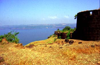
Located 17 km from Dapoli at Harnai, the Suvarnadurg fort consists of two forts. Kanakdurga is the land fort and Suvarnadurga is the sea fort. The forts were originally built by the Adil Shahi dynasty and later captured and fortified by Chatrapati Shivaji Maharaj in 1660. Once there was a tunnel connecting both the forts but now the only way to get to Suvarnadurga is by boat. However, currently there is no regular boat service to the fort and one has to arrange for a ferry from the local fishermen. There is a lighthouse inside the Kanakdurga fort.

Dolphin and Turtle Festival
MTDC hosted the first ever Dolphin and Turtle Festival at Murud and Velas in 2013.
Being a long beach, Murud Harnai, hosted a variety of colorful and engaging activities in association with Suvarna Durga Paryatan Vikas Bahu Udeshiya Seva Sanghatna. Tourists enchanted with many entertaining and participative activities like Beach Cricket, beach sports
and sand sculptures. The local Malwani cuisine and the best quality fish from Kardhe served, along with relishes like Modak and Solakadi that tickle the taste buds of the visitors. The first mango of the season also up for taste at the festival. 
  
Along with Dolphin spotting, cultural programmes arranged by Cultural Department of Maharashtra like ‘Zakhdi Nrutya’ that make tourists dance to the tunes of folk music. A becharming beach musical night mesmerize audience, where renowned singers render Bollywood, Hindi and marathi bhavgeet songs based on the theme of sea. About 6000 tourists witnessed this extravaganza and boarded home stays at Murud Harnai during the Festivals.  

Velas hosts the nesting of endangered Olive Ridley Turtles that migrate thousands of miles to
lay their eggs on the shores of the Arabian Sea at Maharashtra. Velas is a mere one‐and‐a‐half
hour’s drive from Murud Harnai. MTDC, in association with Kasav Mitra Mandal, has arranged 500 tourist stays to witness this unusual phenomenon of turtle hatching and the inception of their journey to the Sea. Contact persons Mr.Shailesh More: 9422433639 – Murud Harnai. Mohan Upadhye : 8983767388 – Velas  

Panhalakaji Caves
Main article: Panhalakaji Caves
Located on the Dapoli-Dabhil Pangari road is a place called Panhalekaji and can also be accessed from Khed via Vakavali & Tetavali. The “Leni” or caves at Panhalekaji are a must-see. You can drive up to the caves. The place is situated deep in the valley near the confluence of the ‘Kotjai’ and ‘Dhakti’ rivers. You can watch many birds and reptiles in the surrounding jungle and river. There are 29 caves and many sculptures around the area. The whole area is very beautiful. according to villager there are 15 to 16 crocodiles in river.

How to reach Panhalakaji
Panhalekaji is situated around 21 km from Dapoli. State Transport (ST) buses run between Dapoli and Panhalekaji. You can also hire an auto rickshaw or drive down. Rented jeeps / cars are available.
Directions from Dapoli to Panhalekaji (shorter route):
• From Dapoli bus stand, take the second left at Kelaskar Naka towards Dabhol
• Turn left near Nante towards Panhalekaji
(Road Route: Dapoli – Kelaskar Naka – Jalgaon – Nante – Panhalekaji)
Directions from Dapoli to Panhalekaji via Wakawali:
• From Dapoli bus stand proceed towards Khed
• Turn right at Wakawali
• Continue on this road till you reach a ‘T’ junction (the left branch goes towards Unhavare and the right branch towards Panhalekaji). Turn right towards Panhalekaji
• This road slopes down towards Dabhil-Pangari. You have to turn right just before the slope ends on the big left curve. This will take you to Panhalekaji
(Road Route: Dapoli – Kumbhve – Wakawali – Gavtale – Panhalekaji)
Unhavare - Hot Water Springs
There are natural hot water springs at Unhavare Village, which is 35 km from Dapoli (Near Panhalekaji caves).[citation needed] Unhavare, 21 km from Vakavali & 17 km from Tetavali's is Dr. Deodhar farms (called keshav Baug) Dr Deodhar is an Expert In Algae from Bombay University, Has a guest house for tourists. The Hot springs are its only attraction. Lots of people from surrounding areas come here regularly to bath in the Hot Sulphur water springs. Separate shelters are made for men and women to take a dip in the rejuvenating hot water. The water is said to cure skin ailments. There are no charges for taking a bath here. There is a small masjid as well as school opposite to hot water. There is also "Mahamai Gram Devata Mandir" as well as "Vidya Mandir High School, starwin farare cricket ground known as "HUMBER" & a very beautiful farare masjid..

Kadyavarcha Ganpati
This Ganesh temple is at Anjarle village which comes under Dapoli taluka. Anjarle is famous for the "Kadyawarcha Ganpati" (Ganesh temple situated on a cliff). This ancient and magnificent Ganesh temple was originally constructed using wooden pillars in around 1150AD. It was renovated during the period between 1768 and 1780. At one time, people used to cross Anjarle creek (Jog River) in a boat and then climb the hill using steps that go through the Anjarle village. Recently a bridge has been constructed and you can take your car right up to the entrance of the temple.

The Ganesh idol is right-sided. This means that its trunk curves towards the right, ("Ujavya Sondecha Ganpati") which is very rare. Kadyawarcha Ganpati is the live deity (a jagrut daiwat) who responds to distress calls of common people (navsala pavnara Ganpati). The temple has a stone staircase on the right hand side to reach to the top of the temple (Kalas). You can get a magnificent view of the thick plantation of coconut trees, betel nut trees, Suvarnadurg Fort, blue sea and surrounding hills from the top. There is a pond in front of the temple where you can feed big fish and turtles. Beside the Ganesh temple there is a small but beautiful temple of Lord Shiva.

Keshavraj Temple
This location is between Dapoli and Asud Pul. It is said that this temple is "pandavkaleen" meaning that it has its origin more than 1000 years ago. The access is via Dabkewadi and after crossing the small river, the steep climb is refreshing. At this elevation, the fresh water is a marvel and is said to be originating from a tree trunk. this fresh water flows for 24/7 and throughout the year. The SHREE KESHAVRAJ "murti" is worth the darshan.
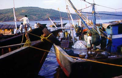

Harnai Fish Market
Harnai fish market is assumed to be one of the largest supplier of fish to Maharashtra and also Export. Many kinds of fishes including lobsters are to be seen in the market. There is an Auction carried on daily basis on the beach. 

Murud Beach (Place of Dolphin watch!)
Murud is a small town on the sea coast, about 12 kilometers from Dapoli. It boasts of one of the most beautiful and longest beach in Konkan region. One can also go for watching Dolphins little far away from the beach, on the local ferry available.

At the centre of the town is the Durga Devi Temple. This temple was built in the 18th century and has 28 exquisitely carved wooden pillars supporting the main porch. On the left of the entrance is a huge bell. This is supposed to have been captured by Chimaji appa Peshwa from the Portuguese in Vasai.

Dhondo Keshav Karve was born in Murud. The town's main square has a bust of this great personality.

Mandivali
Mandivali is a small town 40 km away from Dapoli, which is between Kelshi to Mandangarh City. Mandangarh City is 35 km far from Mandivali. Well educated and skills person working in Mumbai and Abroad. Jama Masjid Mandivali is available for Muslim prayer. They have strong unity in Village and respect all religions.

Dabhol
Dabhol is a port which is 28 km away from Dapoli. The famous Dabhol Power Station is erected near Dabhol by Enron, Which is now known as Ratnagiri Gas and Power Private Limited. This RGPPL was incorporated on 8 July 2005 and is promoted by NTPC Limited and GAIL (India) Limited. The company was set up to take over and revive the assets of Dabhol Power Company Project. RGPPL owns an Integrated Power generation and Re-gasified LNG facility. The power station is India's largest operating gas based combined cycle power station.
Bharati Shipyard Ltd operates from the port.

There is an ancient temple Chandika Devi temple. The idol of Goddess Chandika here, believed to be have formed naturally on its own (Swayambhu) and the temple is underground in a natural cave. To reach the deity, you have to pass through a low darkened passage. No light is allowed inside except that of oil lamp. There is a live spring of fresh water nearby which water all around the year has. Every year pilgrims throng here during Navaratri. This temple used to be frequently visited by Chatrapati Shivaji Maharaj. 

Near to Dabhol there is a small village named Navse where the Bharti Ship Yard has developed and there is a Darga on the hill's of Navse which is called Balla pir which is attractive tourist to go there. 

History of Dapoli

Dapoli or Camp Dapoli (17° 45' N, 73° 10' E; p. 3,958), the head-quarters of Dapoli taluka, stands on an open plain. In 1818, Dapoli was fixed as the military station of the southern Konkan. In 1840, the regular troops were withdrawn. A veteran battalion was kept till 1857, and when this also was abolished, [Nairne's Konkan, 129.] the cantonment was broken up.

In 1862, the headquarters of the old Suvanadurg sub-division was moved from fort Goval at Harnai to Dapoli. Here also are the remains of the former military lines and the old and still habitable quarter guard. In a corner of the open plain, and divided from the market by the Harnai-Khed road, stands in dilapidated condition one of the chief features of the by-gone days, the picturesque old English church with a square tower and belfry. In 1878, the Societies for the Propagation of the Gospel removed their orphanage from Bombay to Dapoli. At present, the missionaries have left the church.

A DIARY OF A TOURIST/VISITOR
Text and Photographs Nilesh Korgaonkar 
Source http://www.rediff.com/travel/1998/oct/28konk3.htm

Dapoli

Suwarnadurga fort
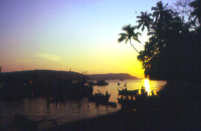
The conventional route to the town of Dapoli bifurcates from the main NH 17. But if you are heading there directly from Srivardhan, it is better to take another parallel road that comes up through the town of Mandangarh. Just before the town of Goregaon turn south for Ambet and Mandangarh. It's a great shortcut. But Dapoli is not on the coastline. Head for the fishing villages of Harnai and Anjarle, which are beyond it. The Suwarnadurg fort is located on an island not far off from the mainland, near Harnai.
The stretch of coast west of Dapoli is apparently popular with the locals. If you carry on beyond the main town towards the fishing village of Harnai, just before the road turns north along the coastline, about four km short of Harnai at Murud, you will come across a group of signposts advertising hotels. It's approaching road is three-four km long, unmetalled and pretty rough with steep gradients. The hotels are near the village of Karde and are probably illegal constructions as they are locate bang on small but very scenic beaches. They offer very basic, but comfortable accommodation and good coastal cuisine of fresh fried fish. The road peters out south of the last hotel. But beyond there are gently rolling hills, an ancient seaside temple and some tiny hamlets -– ingredients that make for some good solitary walks.
There is another minor, smaller road that goes to the village of Burundi from Dapoli. The Hotel Sagar Savli, with just four rooms to let, is located just short of the village where the road ends. The drive is picture perfect with a good road. Local cabs also ply along this road. The beach is beautiful and though you have to book in advance -- preferably from Bombay -- even if you cannot find place to stay, its worth the trouble to visit.

Dabhol

Dabhol jettyAnother road from Dapoli goes to the south where it ends at the mouth of the Vashishti river at the town of Dabhol – of the Dabhol Power Corporation and Enron Power Project fame. The project is coming up on the other side of the river, though it takes its name from this town.
If you are on a two-wheeler or travelling by bus, this is the town to head for to cross over to the other side of the Vashishti and continue down the coast using the ferry. The ferry services from Dabhol commence from 0730 hours to 1800 hours. However, it is better to check the exact timings at the port office near the jetty. The ferry takes you to the jetty at Veldur and the arrival and departure of the buses from there is synchronised with that of the ferry. If you have bypassed Dapoli completely, then you can take a ferry service from Chiplun and sail down the Vaishishti river right up to its mouth at Dabhol or Veldur. The ferry departs from Chiplun early in the morning at about 0400 hours and returns later in the day sometime in the late afternoon.
Evening light at Dabhol bundar after the boats have offloaded their
catchDabhol itself is not much of a place, consisting of just a solitary road and a fishing jetty. But with the coming up of the power project, it is slowly gaining importance and is quite likely to be completely transformed in a few years. There isn't much to see and one can just while away time by taking lazy walks along the road. In the evening, the jetty comes alive as fishermen with their catch come in and auction it to middlemen, who immediately load it into trucks for transport inland. A local market sprouts up nearby at this time and if you have the wherewithal to cook your own meals, you can get a bargain price for some of the freshest fish you are likely to taste.

Anjanvel

GopalgarhThe village of Anjanvel lies on the opposite side of the river mouth. To get there, take the early morning ferry to the jetty at Veldur as Anjanvel does not have its own jetty. The bus that goes from Veldur further south, first goes to Anjanvel to pick up more passengers. Alight at the bottom of the steep slope where Anjanvel’s makeshift bus stop is located. Ask for the fort of Gopalgarh and the lighthouse of Tolkeshwar. Scamper up the slope through the village to battlements of the fort.
As you emerge through the trees and fields, and negotiate the final gentle plateau, a breathtaking view of the ocean dashing on the rocks below awaits you. The sight of -- ramparts of the ruined fort snaking downwards, rugged cliffs reaching out to sea and the lighthouse with two ancient temples nearby -- completes a truly stunning sight. The gentle chugging of a passing fishing trawler only adds to the beauty of the scene. I fervently wish that the construction of the project nearby does not, in any way, disturb this pristine scenery.
Tolkeshwar lighthouseWhen I usually visit Anjanvel, I drive from Chiplun and Guhaghar. But during our last visit, we left our car at Dabhol and took the ferry to Veldur and the bus to Anjanvel. It was the last week of November and the fishing season was in full swing. From our high vantage point next to the Tolkeshwar lighthouse we could see the fishing trawlers hard at work hauling their nets. I couldn't but help comparing the scene to a typical busy day at the business district in any of todays large cities, where city slickers similarly went about their business. Only here, there was no noise, no pushing and shoving, no sweat and grime -- just turquoise waters and a blue sky and every trawler minding its own business.

Places to Stay

View from GuhagharSrivardhan has only lodges with basic amenities. None of them can be booked in advance for want of any contact numbers in Mumbai. But you should not have any problem in finding accommodation if you are not too fussy and are only interested in spending a night or two.
Harihareshwar, a temple village south of Srivardhan and not very far away has a tent colony run by the MTDC (phone: 02147-26036). Bookings are better done at Mumbai before starting your trip.
Surprisingly Dapoli and the area around it has plenty of accommodation to cater to the budget traveller. Staying in Dapoli should not be a problem. But the hotels located along the coastline that we found were almost always full up.

Getting Around.

There are plenty of local buses that ply from the main bus terminus at Dapoli further to the west to the villages of Anjarle via Harnai, to Dabhol and Burundi. Check the timings for your destination on the timetable that will be displayed prominently or ask at the enquiry counter. If you are not on a restricted budget avail of the a chauffeur-driven rickshaw cab. Buses may not ply to all the hotels mentioned here, especially those that are on the rough track. You may have to get off and walk a little from the main road. Ask the bus conductor to let you know when the junction approaches. 

RATNAGIRI: ST Bus phone numbers (STD Code and phone number)
Ratnagiri 2352222340
Mandangad 2350225226
Dapoli 2358282003
Khed 2356263026
Chiplun 2355252003
Guhagar 2359240226
Lanja 2351230022
Rajapur2353222029
Devrukh2354240038

CHIPLUN


Chiplun (Chiplun T.; 17° 30' N, 73° 30' E; p. 15,847), the headquarters of Chiplun taluka, is situated 108 miles south-east of Bombay and twenty-five miles from sea, on the south bank of the Vasishthi river, which, up to Govalkot, one and a half miles from Chiplun, is navigable for boats of about fifteen tons. [At Govalkot around 1870, stone quays were built for loading and discharging cargo. From Govalkot to Chiplun, one and a half miles, runs a narrow tidal; gullet, up which only flat bottomed boats can work. At the head of the Chiplun market is a pier, made soon after the territory was gained by the British. Owing to the silting of the creek, it is little used, most of the traffic being carried on by trucks.] The nearest railway station is Karad, 60 miles to the south-east.

TRADE.

At the head of a navigable river and near the entrance to the Kumbharli pass, one of the easiest routes from the Deccan to the sea, Chiplun was always a good centre of trade. The chief articles received from the Deccan were cotton, gur, clarified butter, oil, grain, turmeric, and chillies; and from Bombay, most of them to be sent on to the Deccan, piece-goods, metals and other miscellaneous articles.

At present mill-made cloth coming from Malegaon, Ichalkaranji, Bombay, etc., has captured the local market. As a result the local handloom industry which was thriving in the last decade has received a set-back. Chiplun can no longer boast of being a feeding centre for surrounding talukas. Gur, Chillies, tobacco, sugar and grains are imported from up-ghats while Bombay supplies cloth.

Population.

Of the total population of 15,847, according to the Census figures of 1951, the agricultural classes number 2,681 and the non-agricultural classes 13,166. Of the latter, 2,509 persons derive their principal means of livelihood from production other than cultivation; 3,555 persons from commerce; 1,617 persons from transport; and 5,485 persons from other services and miscellaneous sources.

Municipality.

Chiplun municipality was established in 1876, and is now governed under the Bombay District Municipal Act, 1901. It is composed of 19 members, all elected. There are two seats reserved for women and one for the Scheduled Castes. The municipality elects a managing committee and committees for sanitation, dispensary, schools and shops and establishments.

For the year 1956-57, the total income of the municipality excluding extraordinary and debt heads, amounted to Rs. 3,12,030; municipal rates and taxes being Rs. 2,61,182; revenue derived from municipal property and powers apart from taxation Rs. 7,155; grants and contributions Rs. 17,683; and miscellaneous Rs. 26,010. The total expenditure for the same year, excluding extraordinary and debt heads, amounted to Rs. 2,03,426; general administration and collection charges being Rs. 38,860; public safety Rs. 25,014; public health and convenience Rs. 54,033; public works Rs. 65,913; public instruction Rs. 15,537; and miscellaneous Rs. 4,069.

There are two sources of water supply. One nalla caters for a part of the town and one pucca built pick-up-weir across the river serves the rest of the town. However, water supply is scanty during April and May. Tail water when released from Pophali at the lowest stage of the Koyna Project will help to solve this difficulty to a great extent. Road watering is done by well water pumped up by diesel pump.

There is no proper drainage system at present. It is difficult to arrange for under-ground drainage, as the town is very little above the sea level. A drainage system has been taken in hand (1959).

There is compulsory primary education, managed by the District School Board, the municipality paying its statutory contribution. A public library called the Lokamanya Tijak Smarak Vachan Mandir is paid grant-in-aid by the municipality to the extent of Rs. 500 to Rs. 750 a year.

The municipality has recently constructed a fish market at a cost of about Rs. 30,000. There are a few dispensaries and maternity hospitals in the town besides a dispensary and a maternity ward run by the municipality, which are located in the municipal office building. Government maintains a veterinary dispensary in the town.

For fire service, the municipality has one truck fire-fighter which is used also as a road-watering vehicle.

Out of the total road mileage of 12.50, five miles are asphalted, four miles metalled and three and a half miles kaccha roads.

There is no municipal cremation or burial ground. The Brahman Vaishya and Shimpi communities have their own cremation grounds. The Muhammedans also have their burial ground privately managed.

Somewhat separated from the town and half way up the road to the Public Works Department Bungalow, is a decent, new building for State Transport Stand and a canteen.

History.

Chiplun, the first home of the Konkanasth or Chitpavan Brahmans, according to local traditions, stocked with Brahmans and supplied with sixty ponds and sixty gardens by Parashuram, the reclaimer of the Konkan, has for long been a place of consequence. [A stone was found at Chiplun bearing the date 1156 (10788), Bom. As. Soc. Meeting, September 1879.] In the seventeenth century it was a great village, very populous and plentifully stored with all provisions. [Ogilby's (1670) Atlas, V. 247. ] In 1818, it was taken by a body of Ramoshis, but abandoned by them on the approach of British forces. [Nairne's Konkan, 116.] In 1819, it was an insignificant village, but bid fair to be, Rajapur excepted, one of the chief trade centres of the southern Konkan. During the dry season Vanjaris, Vanus, and a few Parsees, came, set up temporary booths, and left when the rains fell. [Collector to Govt. 15th July 1819; Rev. Diaries 142 of 1819, 2375.] In 1821, it is spoken of as a place of very important trade. [Bom. Rev. Rec. 16 of 1821, 638.] In 1826, Chiplun was a town of considerable importance. The river was navigable for boats of about eight tons (30 Khandis) close to, and for boats of about fifteen tons (60 Khandis) within three miles of the town. [Clune's Itinerary, "38.] The building now used as a Government office was built as a rest house for Bajirav Peshva, who for some years (1812-1815) came down the Kumbharli pass to visit his palace at Guhagar near Dabhol. [Nairne's Konkan. 121.]

Rock Temples.

About a quarter of a mile south of the town is a series of rock temples. Of these the chief is tolerably high, with, at its inner end, a Buddhist relic shrine, daghoba. There are also two or three smaller caves, and a deep thirteen feet square pond. Three stages on the road from Chiplun to Karad in Satara is another series of Buddhist caves, consisting of a room with a small round relic shrine, six feet in diameter and a hall, shala, 19' by 18', with a raised seat at one corner and three recesses at the inner end. [Jour. Bom. Royal As. Soc. IV. 342.]

Govalkot Fort.

At Chiplun on a detached hill commanding the creek, and surrounded on nearly all sides by higher hills, is the fort of Govalkot. This is said to have, at different times, belonged to the Habshi, Angre, and the Peshva, and Angre is said to have besieged it for twelve years. At the top of the fort is a fine reservoir. [Nairne's MS. notes.]

A bridge has been constructed recently linking Govajkot fort with Chiplun town. To speed up the carrying of goods and heavy machinery to and from the Koyna Project site a crane to load and unload the cargo from ships plying between Dabhol and Goval has been erected at Goval. A road from Govalkot fort to Pophali was recently renovated.

Of the sixty legendary ponds dug by Parashuram,, only Ram-Tirth holds some water. The walls of Ram Tirth and the buildings on its bank are in a dilapidated condition which gives a deserted look to the surroundings.

Related Posts Plugin for WordPress, Blogger...

Popular Posts